10 Best Hikes In The National Parks Near Mexico City
Mexico City is emerging as a world-class hiking destination because, within a few hours of the city, you have 10 spectacular national parks to explore.
Situated at 2,240 meters (7,349 feet) above sea level, Mexico City is one of the highest-elevation cities in the world. Due to its subtropical location and high elevation, it has an excellent climate for hiking and outdoor recreation.
In the vast mountains and high alpine forests surrounding Mexico City, you will have sweeping vistas of some of the highest volcanos in the Americas. If you are planning a hiking holiday, you can also enjoy some more relaxed days in the valleys visiting spectacular archeological sites like Teotihuacán and the Great Pyramid of Cholula.
As one of the 6 cradles of civilization, the central valleys and mountains of Mexico are filled with ancient history, mythical lore and indigenous cultures deeply rooted in the land.
Here are some of the best hikes near Mexico City in the most beautiful national parks that you can visit on a day trip:
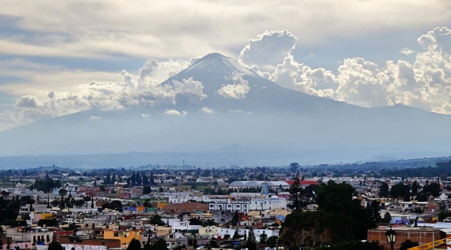
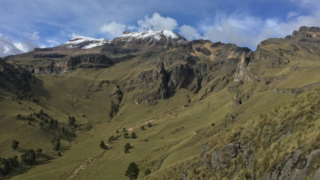
1. Iztaccíhuatl–Popocatépetl National Park
Length: 5.3 km
Elevation gain: 574 m
Route type: Out & back
Trail Map: AllTrails
This alpine route to the summit of Iztaccíhuatl is highly challenging and is not for beginners. Fortunately, there are lots of epic hikes for all skill levels in the lower cloud forests and the upper alpine meadows.
The best hike in the national park is the 3-hour La Joyita – Portillo 3 route, which takes you from the La Joyita base camp where most ascents of Iztaccíhuatl begin to the third alpine pass on the way to the summit.
If you want to climb Iztaccíhuatl, you can check out my hiking guide to Iztaccíhuatl–Popocatépetl National Park. The trail to the summit requires acclimatization to the high altitude and involves 12.2 km and 1,337 m of elevation gain, which takes 10-12 hours.
The Paso de Cortés is also a great challenging hike in the national park, it covers 15.3 km and 705 m, which takes about 5-6 hours. It is not possible to climb El Popocatépetl because it is an active volcano with regular eruptions.
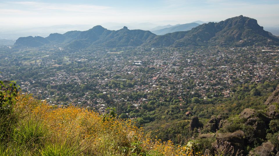
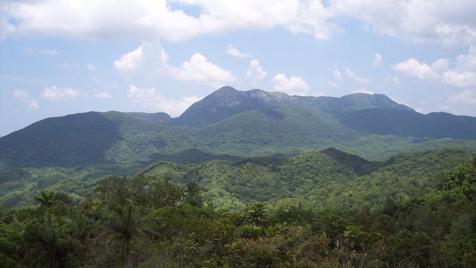
2. El Tepozteco National Park
Length: 2.6 km
Elevation gain: 341 m
Route type: Out & back
Trail Map: AllTrails
Just over an hour from Mexico City, you can find peace and tranquillity in the sacred valley of Tepoztlán. Here you will find excellent hiking and I recommend staying here for a few days because this area has a lot of great hikes.
Of all the 177 designated Pueblos Mágicos in Mexico, Tepoztlán may be the most magical. This valley is an ancient pilgrimage spot and one of the centers for magic and mysticism in Mexico. As a result, you’ll find a lot of retreat centers here for exploring ancient wisdom, consciousness and meditation.
The must-do hike is to the pyramid in Tepozteco National Park. I also highly recommend climbing up to Cerro Del Tepozteco to see awe-inspiring panoramic views of the entire valley of Tepoztlán.
There are many more excellent hikes in the Tepoztlán area, including the Ocotitlán West Loop, Cerro Cematzin and Poza de Quetzalcóatl. I have covered them in my Tepoztlán hiking guide.
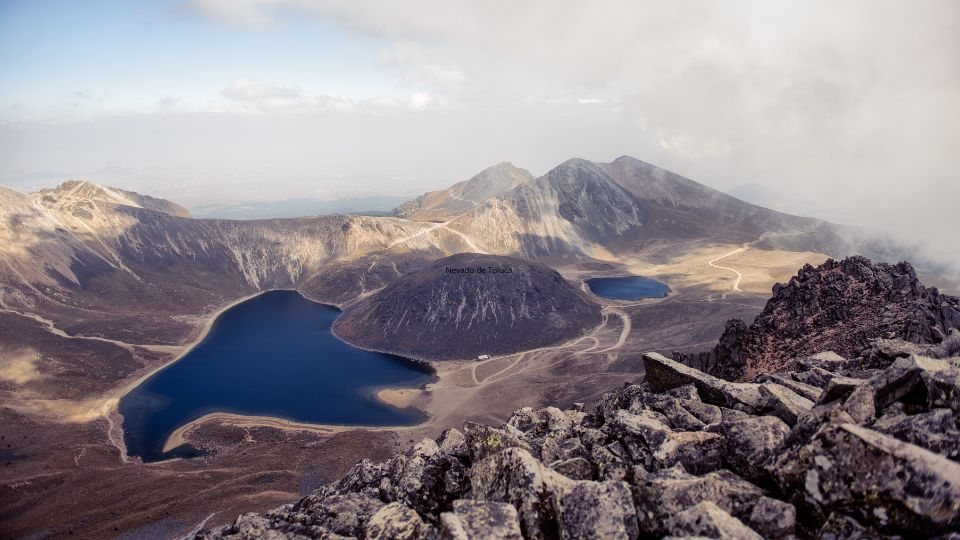
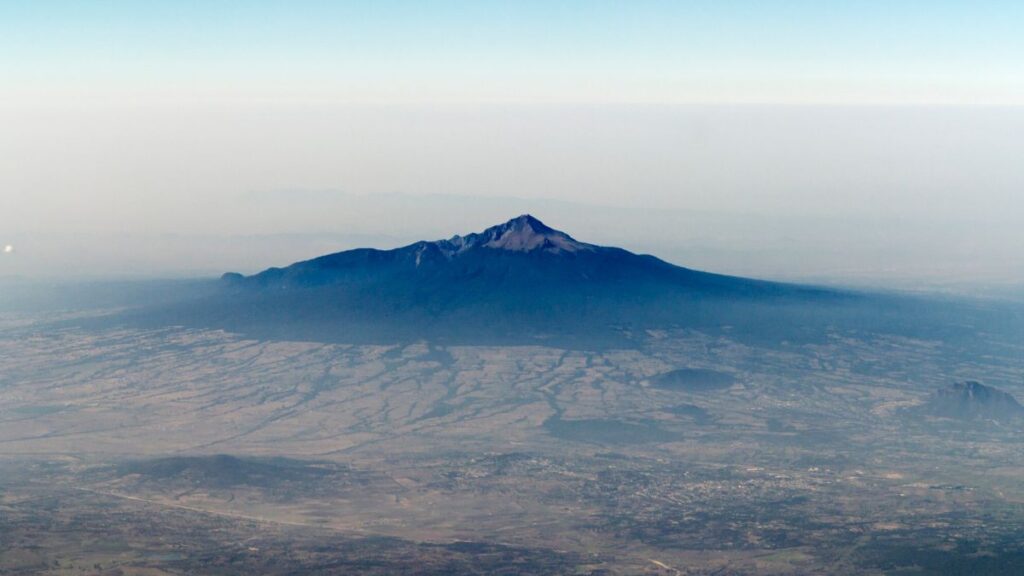
3. Nevado de Toluca National Park
Length: 6.9 km
Elevation gain: 658 m
Route type: Out & back
Trail Map: AllTrails
Nevado de Toluca is the 4th highest peak in Mexico at 4,680 m (15,350 feet). It is very popular because it is a much easier hike than the other highest volcanos Pico de Orizaba, Volcan Iztaccíhuatl and El Popocatépetl because you start at a much higher altitude.
Nevado de Toluca is often called by the Nahuatl name Xinantecatl, which is usually translated as The Naked Lord. Most of the day trips to Nevado de Toluca visit the twin lagoons within the volcanic crater, one of the lakes is green and the other is blue, which is a relatively easy hike.
If you are more adventurous than the average person and you’re also in excellent physical shape Nevado de Toluca can be summited in 6-7 hours. It’s a good idea to acclimatize with at least a few days in Mexico City and a night camping in the national park before doing the summit.
Apart from the high altitude, it’s not a particularly difficult hike. The hardest part is a challenging class 2-3 scramble near the summit. There’s a much easier hike to a viewpoint near the summit called the Ruta Del Campanario.
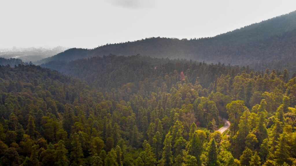
4. Cumbres del Ajusco National Park
Length: 6 km
Elevation gain: 654 m
Route type: Loop
Trail Map: AllTrails
Just south of Mexico City overlooking this sprawling metropolis you will find Mexico’s oldest biosphere reserve Desierto De Los Leones and Cumbres del Ajusco National Park.
Pico del Águila, the highest peak in Cumbres del Ajusco National Park at 3,900 metres (12,800 feet) towers over the southwest of Mexico City.
It can be hiked in as little as 3-4 hours with the most direct Pico del Águila route. If you want to make it a day hike on a more challenging loop route, I’d recommend doing Circuito Cumbres del Ajusco or Cumbres del Ajusco Loop via el Abrevadero.
5. Desierto De Los Leones National Park
Length: 7.9 km
Elevation gain: 502 m
Route type: Loop
Trail Map: AllTrails
There are a number of excellent in Desierto De Los Leones. I love the forests in this national park, it’s a great area to discover a wide variety of plants, birds and mushrooms.
The park is considered to be the oldest protected biosphere in Mexico as it was originally declared a forest reserve in 1876 with the intent of conserving its fresh water springs that supply Mexico City. In 1917, it was officially declared a national park.
According to Wikipedia, the term Desierto is used in this context in the archaic sense of “wild, sparsely populated area” rather than in reference to an arid environment. Leones (‘Lions’) refers not to the big cats but rather to the original landlord’s surname.
If you want a shorter hike there is Cerro de Coconetla via Los Dinamos but I recommend doing the Circuito la Bodega or La Bodega Miradores.
6. La Malinche National Park
Length: 12.1 km
Elevation gain: 1,278 m
Route type: Out & back
Trail Map: AllTrails
If you want to climb one of Mexico’s highest volcanos then La Malinche is one of the most accessible climbs in the Central Valleys of Mexico. At 4,461 m (14635 feet) above sea level, it is the 6th-highest peak in Mexico.
Like all the high volcanos in Mexico, this hike to the summit is steep and highly challenging. It can be done as a day trip from Puebla or you can drive 3 hours from Mexico City and stay in a cabin at the base of the volcano.
La Malinche is a still active volcano and it is also known as Malintzin. It is named after the infamous Nahua woman from the Mexican Gulf Coast who was given to Hernán Cortés as a slave and consort.
Her deep knowledge of the indigenous cultures of Mexico was an important contributing factor to the Spanish conquest of the Aztec Empire (1519–1521) as she acted an interpreter, advisor, and intermediary for Cortés. She later gave birth to their first son, Martín who was one of the first Mestizos (people of mixed European and Indigenous American ancestry) to be born in Mexico.
This hike requires crampons and an ice axe if it has snowed recently and it is recommended that you hire a guide for safety and route finding. On a clear day, you can see Iztaccíhuatl, Popocatépetl and Pico de Orizaba from the upper alpine of La Malinche.
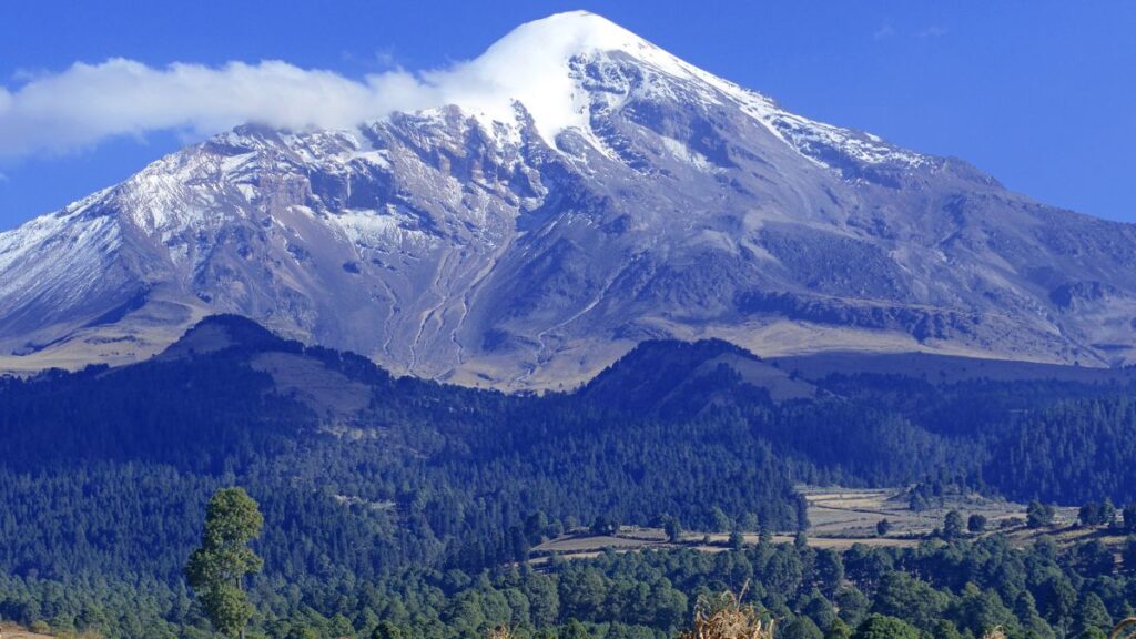
7. Pico de Orizaba National Park
Length: 12.4 km
Elevation gain: 1,563 m
Route type: Out & back
Trail Map: AllTrails
If you want to climb the highest mountain in Mexico and the tallest volcano in North America then 5,636 m (18,491 ft) Pico de Orizaba is waiting for you.
To climb this mountain you’re going to need to be in excellent fitness, have some mountaineering experience and you’re going to want to hire a local mountain guide.
The most common way to the summit is the Pico de Orizaba Cara Sur (Citlaltépetl) route. Prepare yourself with lots of loose gravel, volcanic ash and scree. You will also need trekking poles, crampons and an ice axe.
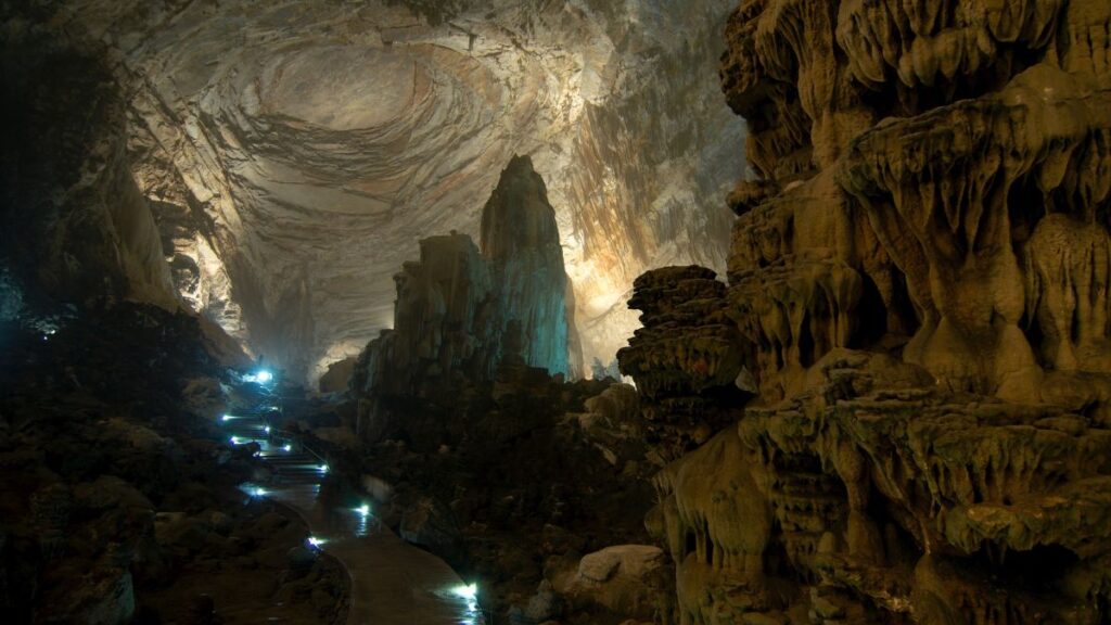
8. Grutas de Cacahuamilpa National Park
Length: 7.4 km
Elevation gain: 447 m
Route type: Out & back
Trail Map: AllTrails
Grutas De Cacahuamilpa is one of the largest cave systems in the world. If you want the ultimate caving experience, tours of the open cave system run every hour and last 2-3 hours.
There is a famous hiking trail in the cave system called the Río Chontalcoatlan. You’ll definitely want to hire a local guide for this extraordinary hiking and spelunking experience.
You can also book expeditions that go much deeper into the cave system. If you visit this area, I’d also recommend visiting the extraordinary archeological site of Xochicalco in the mountains overlooking the city of Cuernavaca.
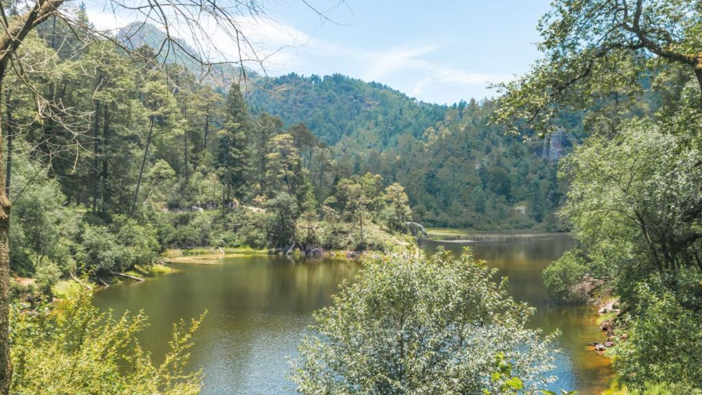
9. Lagunas de Zempoala National Park
Length: 6.4 km
Elevation gain: 606 m
Route type: Out & back
Trail Map: AllTrails
Lagunas de Zempoala is a beautiful area just south of Mexico City that consists of a group of seven lagoons. In the indigenous Nahuatl language, “Zempoala” means “place of many waters”.
In this high-altitude area of dense forests, you will find excellent hiking trails and viewpoints overlooking the surrounding valleys and the volcanos to both the east and west.
The best hike that I recommend doing in Lagunas de Zempoala is Cerro Alumbres, which begins at the lagoons and continues up to a spectacular viewpoint. You can easily combine this hike with a series of other short hikes to make a full day of hiking in this area.
10. El Rosario Monarch Butterfly Biosphere Reserve

Length: 4 km
Elevation gain: 426 m
Route type: Out & back
Trail Map: AllTrails
A couple of hours west of Mexico City you will find the best place in North America for observing monarch butterflies. A series of 3 monarch butterfly reserves are home to the majority of butterflies that visit the cloud forests of Central Mexico each winter.
The season to see the butterflies is from November to March and you can easily visit the butterfly sanctuaries as a day tour from Mexico City. The reserves are managed by local indigenous peoples and ecotourism is a key source of income for these people so you must hire a local guide to hike in the area.
El Rosario is the largest and most popular butterfly sanctuary in the state of Michoacán and is about a 3-hour drive from the city. The other butterfly sanctuary worth visiting is Piedra Herrada, which is a shorter 2-hour drive from Mexico City and near the town of Valle De Bravo, which also has a lot of great hiking trails.

