10 Best Hiking Trails In The National Parks of Colombia
Colombia is a hiker’s paradise, offering the highest biodiversity per square mile in the world and awe-inspiring wild ecosystems that few countries can match. From the snow-capped peaks of the Andes to the lush Amazon rainforest, from pristine Caribbean beaches to high-altitude páramo ecosystems, Colombia’s national parks protect some of the most breathtaking natural environments on the planet.
With 59 national parks and protected areas spanning over 200,000 square kilometers (77,220 square miles) – approximately one-sixth of Colombia’s land mass – the country provides endless opportunities for outdoor enthusiasts to explore its natural wonders. These protected areas not only showcase Colombia’s exceptional natural beauty but they also play a crucial role in preserving the country’s remarkable biodiversity, which is second only to Brazil (a country that 7x larger than Colombia).
Hiking in Colombia’s national parks offers visitors the chance to experience a remarkable range of ecosystems, often within relatively short distances of each other. For example, the pyramid-shaped Sierra Nevada de Santa Marta on Colombia’s Northern Caribbean coast contains nearly every climatic zone on Earth from the climate of tropical jungles at sea level to arctic glaciers at elevations exceeding 5,500 meters (18,000 feet).
On a hiking adventure in Colombia, you can witness the transition from tropical forests to alpine tundra, encounter unique flora, fauna and fungi found nowhere else on Earth, and connect with indigenous cultures that have maintained their pre-Hispanic traditional ways of life for centuries.
This guide presents the 10 best hiking trails across Colombia’s national parks, selected for their scenic beauty, unique features, cultural significance, and the quality of the hiking experience they offer. Whether you’re seeking a challenging multi-day trek through remote wilderness or a more accessible day hike with spectacular views, Colombia’s national parks have something to offer every type of hiker.
Before setting out on any of these trails, it’s important to note that many require guides (often mandatory), permits, or advance reservations. Weather conditions can change rapidly, particularly in mountainous regions, and proper preparation is essential. The best time to visit most of Colombia’s hiking destinations is during the dry seasons (December to March and July to August), though this can vary by region.
As you explore these magnificent trails, remember to practice responsible tourism by respecting wildlife, following leave-no-trace principles, and honoring the cultural traditions of local communities. By doing so, you’ll help ensure that Colombia’s natural treasures remain pristine for generations to come.
Let’s embark on a journey through Colombia’s most spectacular hiking trails, each offering a unique window into the country’s natural and cultural heritage.
1. Ciudad Perdida Trek In Sierra Nevada De Santa Marta National Park
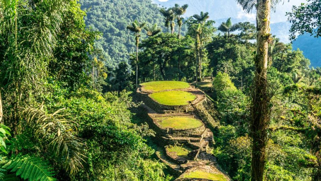
Deep in the lush Sierra Nevada de Santa Marta mountains of northern Colombia lies one of South America’s most remarkable archaeological treasures known as La Ciudad Perdida, or the “The Lost City.” This ancient site predates Peru’s Machu Picchu by approximately 650 years and it offers intrepid hikers not just a glimpse into pre-Columbian history but also an unforgettable journey through one of Colombia’s most biodiverse regions.
The Journey to Colombia’s Lost City
The Ciudad Perdida trek is a challenging 46-kilometer (28-mile) round-trip expedition that typically takes between 4 and 6 days to complete. Beginning in the small town of Machete or El Mamey, about an hour’s drive from Santa Marta, the trail winds through varying terrains of the Sierra Nevada de Santa Marta, the world’s highest coastal mountain range.
What makes this trek particularly special is the immersive experience it offers. As you navigate dense jungle paths, cross refreshing rivers, and climb steep mountain slopes, you’ll pass through territories belonging to indigenous communities including the Kogi, who are direct descendants of the Tairona civilization that built Ciudad Perdida. Many guides are members of these communities, providing authentic cultural insights that enrich the journey.
The trail itself presents a physical challenge, with approximately 2,700 meters (9,000 feet) of elevation gain and loss throughout the trek. Hikers traverse muddy paths, rocky terrain, and numerous river crossings, all while contending with the region’s heat and humidity. However, the route is punctuated by natural swimming holes where you can cool off during the day, and each night is spent in basic but comfortable camps equipped with hammocks or bunk beds.
Discovering Teyuna: The Archaeological Wonder
The culmination of this arduous journey is, of course, the Lost City itself, which is known to the indigenous people as Teyuna. After climbing the famous 1,200 stone steps that lead to the site, hikers are rewarded with the sight of an ancient city comprising 169 terraces carved into the mountainside, along with circular plazas and stone pathways that have withstood the test of time since the 9th century.
Unlike more famous archaeological sites that can be crowded with tourists, Ciudad Perdida offers a more intimate experience. The limited number of trekkers allowed on the trail means you can explore the ruins in relative tranquility, imagining life as it was over a thousand years ago when the Tairona people thrived here.
Planning Your Hike To Ciudad Perdida
It’s important to note that the Ciudad Perdida trek can only be undertaken with authorized tour operators, as the site is located in protected indigenous territory. Companies like Expotur, Wiwa Tours, and Magic Tour offer packages that typically cost between $400-500 USD, including guides, food, and accommodation.
The best time to attempt this trek is during the dry season from December to March, though it’s worth avoiding the peak holiday periods in December and January when the trail can be busier. Proper preparation is essential – quick-dry clothing, good hiking boots, insect repellent, and water purification methods are all must-haves.
While challenging, the Ciudad Perdida trek doesn’t require technical mountaineering skills, making it accessible to hikers with a good level of fitness and determination. The reward – standing among ancient ruins that remained hidden from the outside world until their rediscovery in 1972 – is well worth the effort, offering a profound connection to Colombia’s rich pre-Columbian heritage and natural beauty.
2. Nevado del Tolima Summit In Los Nevados National Park

Rising majestically to 5,221 meters (17,129 feet) above sea level, Nevado del Tolima stands as one of Colombia’s most impressive volcanic peaks. Located in Los Nevados National Park in the heart of the Colombian Andes, this snow-capped giant offers one of the country’s most challenging and rewarding high-altitude hiking experiences.
A Journey Through Diverse Ecosystems
The trek to Nevado del Tolima’s summit is a multi-day adventure that typically begins near the colorful colonial town of Salento or from the Valle de Cocora, famous for its towering wax palms. What makes this hike particularly special is the remarkable ecological transition hikers experience as they ascend through distinct altitudinal zones.
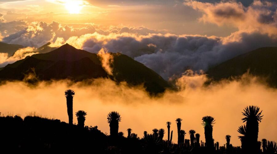
The journey starts in the lush cloud forests at lower elevations, where moss-covered trees and vibrant orchids create an enchanted atmosphere. As you climb higher, the forest gradually gives way to the unique páramo ecosystem – a high-altitude tundra-like environment found only in the northern Andes. Here, the landscape is dominated by frailejones, peculiar plants with fuzzy leaves that have adapted to the harsh conditions of high altitude.
Continuing upward, hikers enter the alpine zone where vegetation becomes increasingly sparse before reaching the snow line and the glaciated upper sections of the volcano. This ecological diversity in a relatively compact area makes the Nevado del Tolima trek a living showcase of Colombia’s remarkable biodiversity.
The Summit Challenge
The final ascent to Tolima’s summit requires technical mountaineering skills and proper acclimatization. At 5,221 meters, the thin air contains roughly half the oxygen found at sea level, making every step a test of endurance. However, those who persevere are rewarded with one of the most spectacular panoramas in Colombia – a 360-degree view encompassing other volcanic peaks of the Los Nevados range, the surrounding Andean landscape, and on clear days, visibility extending to Colombia’s coffee region.
The complete trek typically takes 3-4 days, with the summit attempt usually occurring in the early morning hours of the final day to take advantage of more stable weather conditions and firmer snow. While challenging, standing atop this volcanic giant provides an incomparable sense of achievement and connection to the raw power of the Andean landscape.
Planning Your Hike To Nevado del Tolima
Due to the technical nature of the climb and the risks associated with high-altitude mountaineering, the Nevado del Tolima trek requires a registered guide. These can be arranged in nearby towns like Salento or Manizales, with several reputable agencies offering guided expeditions.
The best time to attempt this trek is during the dry seasons (December to March and July to August), when weather conditions are more stable and the risk of storms is reduced. Proper equipment is essential, including warm layers, technical mountaineering gear for the upper sections, and high-altitude camping equipment.
It’s worth noting that Colombia’s glaciers are retreating rapidly due to climate change, making this experience increasingly precious. The opportunity to stand on one of Colombia’s iconic snow-capped peaks may not be available to future generations, adding a poignant dimension to this already extraordinary adventure.
For those not ready to tackle the summit, Los Nevados National Park offers gentler alternatives, including trails that pass through the páramo to reach glassy lagoons and viewpoints of the glaciers without requiring technical climbing skills. Whichever route you choose, Los Nevados promises an unforgettable encounter with the majestic heights of the Colombian Andes.
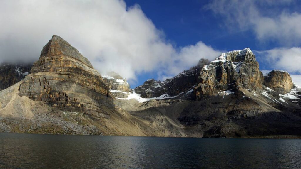
3. El Pulpito del Diablo Trail In El Cocuy National Park

In the remote northeastern reaches of Colombia lies El Cocuy National Park, home to one of the country’s most dramatic and aptly named geological features – El Pulpito del Diablo, or “The Devil’s Pulpit.” This distinctive rock formation, resembling a shard of stone spiking out of a slowly retreating glacier, is the centerpiece of one of Colombia’s most rewarding day hikes.
A Journey to Colombia’s Alpine Wilderness
The El Pulpito del Diablo trail offers hikers a rare opportunity to experience the high-altitude wilderness of the Colombian Andes in its most pristine form. Beginning at Alto de la Cueva at approximately 3,700 meters (12,100 feet) above sea level, the trail traverses through Valle Lagunilla (Valley of Small Lagoons), a landscape that feels worlds away from the tropical image many associate with Colombia.
This 16-kilometer (10-mile) round-trip journey takes hikers through a stark, beautiful landscape dominated by the páramo ecosystem. The route gradually ascends through terrain dotted with frailejones – peculiar plants with fuzzy, silver-green leaves that are uniquely adapted to the harsh conditions of high altitude. These iconic plants, some centuries old, create an almost otherworldly atmosphere as you make your way toward the main attraction.
The Devil’s Pulpit: Nature’s Cathedral
As you approach El Pulpito del Diablo, the landscape becomes increasingly dramatic. The final section involves a challenging scramble over rocky terrain to reach the base of the formation. Rising dramatically against the sky, this vertical rock spire emerges from a glacier like a natural cathedral – a testament to the powerful geological forces that have shaped the Colombian Andes.
While reaching the actual summit of El Pulpito del Diablo requires technical rock climbing skills (a 70-90 meter vertical trad climb), most hikers are content to reach the base of the formation. From this vantage point, you’re rewarded with spectacular panoramic views of alpine tundra, glacial valleys, and the vertiginous mountains that roll into the distance. On clear days, you can see multiple peaks of the Sierra Nevada del Cocuy, including some of Colombia’s highest mountains.
Planning Your El Pulpito del Diablo Hike
The El Pulpito del Diablo trail is one of only three officially open trails in El Cocuy National Park, following restrictions implemented to protect the sacred lands of the resident U’wa indigenous people. A local guide is mandatory and can be arranged in the town of El Cocuy.
While not technically difficult, the trail is challenging due to the high altitude, with the route reaching nearly 4,900 meters (16,000 feet) at its highest point. Proper acclimatization is essential before attempting this hike, and even physically fit hikers may find themselves moving more slowly than usual due to the thin air.
The best time to visit is during the dry season from December to February, when skies are more likely to be clear. Morning starts are recommended to avoid afternoon clouds and potential storms. Warm layers, rain gear, sun protection, and plenty of water are essential, as weather conditions can change rapidly at this altitude.
El Pulpito del Diablo is part of what some guides call the “Climate Change Trail,” as it showcases the effects of global warming on Colombia’s tropical glaciers, which are retreating at an alarming rate. This adds a poignant dimension to the experience, highlighting the fragility of these unique high-altitude ecosystems.
For those willing to venture into Colombia’s remote alpine wilderness, the El Pulpito del Diablo trail offers not just spectacular scenery but also a profound connection to the elemental forces that have shaped this remarkable landscape over millennia.
4. Laguna de la Plaza In El Cocuy National Park
Hidden deep within the rugged terrain of El Cocuy National Park lies one of Colombia’s most pristine alpine treasures – Laguna de la Plaza. This multi-day trek to a stunning high-altitude lake offers adventurous hikers a chance to experience the raw, untamed beauty of the Colombian Andes in its most dramatic form.
The Journey to Colombia’s Alpine Jewel
The trek to Laguna de la Plaza is a challenging 40-kilometer (25-mile) round-trip expedition that typically takes between 3 and 5 days to complete. Beginning from the base camp at El Cocuy National Park, the trail leads hikers through a remarkable progression of Andean landscapes, each more breathtaking than the last.
What makes this trek particularly special is its remoteness. Far fewer visitors venture to Laguna de la Plaza compared to other trails in Colombia, offering a genuine wilderness experience that has become increasingly rare in our connected world. The sense of isolation is profound, with vast stretches of trail where you might encounter no one else, just the sounds of the wind and perhaps the call of an Andean condor circling overhead.
The route traverses through diverse high-altitude ecosystems, with the páramo landscape being particularly captivating. This unique ecosystem, found only in the northern Andes, is characterized by frailejón plants – distinctive species with fuzzy, silver-green leaves that have evolved to withstand the harsh conditions of high altitude. Some of these plants are centuries old, standing like silent sentinels across the windswept landscape.
The Alpine Lake: A Pristine Reward
After days of challenging hiking, the first glimpse of Laguna de la Plaza is an unforgettable moment. Nestled at approximately 4,500 meters (14,764 feet) above sea level, this pristine alpine lake is surrounded by snow-capped peaks and glaciers, its electric-blue waters creating a striking contrast against the stark mountain backdrop.
The lake itself is considered one of the most beautiful in El Cocuy National Park, and indeed in all of Colombia. Its crystal-clear waters reflect the surrounding mountains on calm days, creating a mirror-like effect that doubles the visual impact of the already spectacular scenery. The area around the lake offers numerous vantage points for photography and contemplation, with each angle revealing new perspectives on this high-altitude wonder.
Planning Your Laguna de la Plaza Hike
The trek to Laguna de la Plaza requires excellent physical conditioning and proper acclimatization to high altitude. The trail involves significant elevation gain and challenging terrain, with the thin air at 4,500 meters making physical exertion considerably more demanding than at lower elevations.
A local guide is mandatory for this trek, and can be arranged in the towns of El Cocuy or Güicán. The best time to attempt this journey is during the dry season from December to February, when weather conditions are more stable and trails are less likely to be muddy or obscured.
Camping equipment is essential, as there are no permanent structures along the main trekking circuit. Nights at this altitude can be extremely cold, so proper thermal sleeping bags and warm layers are crucial. Water purification methods are also necessary, though the high-altitude streams and lakes of El Cocuy contain some of the purest water you’ll find anywhere.
It’s worth noting that this hike isn’t always available and depends on the state of the ecosystem and park administration’s judgment. The fragile páramo environment is carefully protected, and access may be restricted during certain periods to allow for ecological recovery.
For those willing to embrace the challenge, the trek to Laguna de la Plaza offers a profound wilderness experience in a landscape often compared only to Patagonia in South America. It’s a journey that connects hikers not just to Colombia’s natural heritage, but to the elemental forces that have shaped these mountains over millions of years.
5. Cabo San Juan Hike In Tayrona National Park
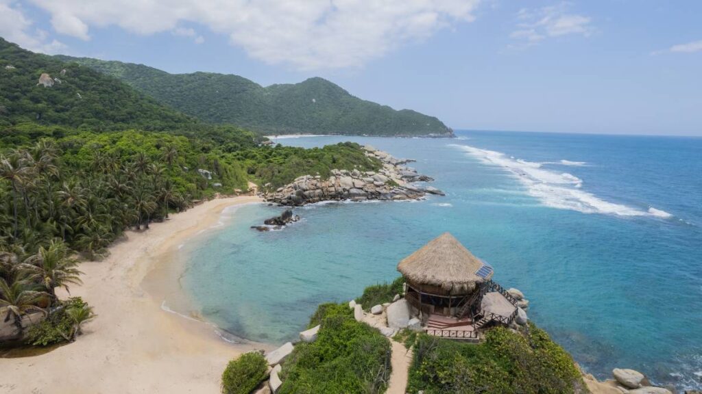
Where the lush foothills of the Sierra Nevada de Santa Marta mountains meet the crystalline waters of the Caribbean Sea lies one of Colombia’s most beloved coastal hikes – the trail to Cabo San Juan in Tayrona National Park. This journey offers a perfect blend of jungle trekking and beach paradise, creating an experience that captures the essence of Colombia’s remarkable natural diversity.
A Coastal Journey Through Jungle and Beach
The Cabo San Juan hike begins at the El Zaino entrance of Tayrona National Park, where visitors can take a short shuttle to the trailhead at Cañaveral. From this point, the adventure unfolds along a well-marked path that alternates between dense tropical forest, rocky coastline, and stretches of golden sand beaches.
What makes this trail particularly special is the constant interplay between jungle and sea. One moment you’re walking under a canopy of trees, listening to the calls of howler monkeys and watching colorful birds flit through the branches; the next, you’re emerging onto a pristine beach with the turquoise Caribbean stretching to the horizon. This dynamic landscape creates a sensory journey that few other hikes in Colombia can match.
The trail passes several beautiful beaches along the way, including Arrecifes and La Piscina, each offering opportunities to rest and swim. La Piscina, protected by a natural coral reef, creates a calm swimming area that lives up to its name (“The Pool”), providing a refreshing break during the hike.
Cabo San Juan: The Iconic Destination
After approximately 2-3 hours of hiking, the trail reaches its crowning jewel – Cabo San Juan. This iconic destination features a distinctive double-bay beach with a small rocky peninsula jutting into the sea. Atop this peninsula sits a small thatched hut that has become one of the most photographed images of Colombia’s Caribbean coast.
The beauty of Cabo San Juan lies in its perfect composition – golden sands meeting crystal-clear waters, backed by lush jungle with the Sierra Nevada mountains visible in the distance. The contrast of colors is striking: the deep greens of the forest, the turquoise blues of the Caribbean, and the golden hues of the beach create a natural palette that seems almost too perfect to be real.
For those wishing to extend their experience, Cabo San Juan offers the opportunity to stay overnight in hammocks or tents, allowing visitors to experience the magic of sunrise and sunset in this paradise setting. Falling asleep to the sound of waves lapping against the shore and waking to the pink glow of dawn over the Caribbean is an experience not easily forgotten.
Planning Your Cabo San Juan Hike
The Cabo San Juan hike is one of Colombia’s more accessible trails, with a moderate difficulty level that makes it suitable for hikers of various experience levels. The main challenges come from the heat and humidity of the Caribbean coast, rather than technical difficulty or extreme elevation changes.
The best time to undertake this hike is during the dry season from December to March, though it’s worth noting that this coincides with the park’s busiest period. Starting early in the morning helps avoid the midday heat and the largest crowds.
It’s important to be aware that Tayrona National Park has a daily visitor limit and is closed for 4 times each year (February 1-15, June 1-15, and October 19-November 2) for ecological recovery and maintenance. Advance planning is essential, especially during peak tourist seasons.
For those who prefer to skip the hike in one direction, boat services are available from the nearby town of Taganga directly to Cabo San Juan, offering the option of hiking only one way.
The Cabo San Juan hike represents the perfect synthesis of Colombia’s natural diversity – a place where mountains, jungle, and sea converge to create one of the most picturesque coastal landscapes in South America. It’s a journey that rewards hikers not just with physical beauty, but with the opportunity to experience the vibrant ecosystem of Colombia’s Caribbean coast in all its glory.
6. Cocora Valley Trail In Los Nevados National Park
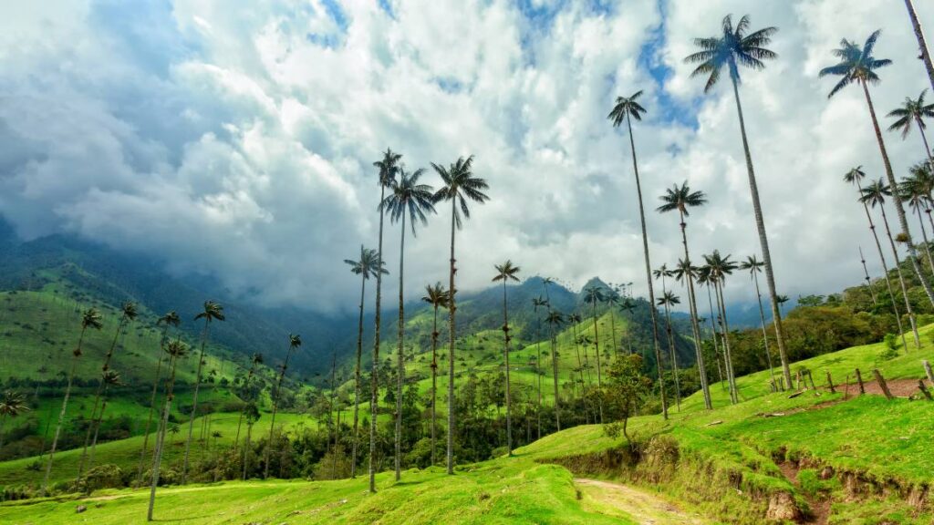
In the verdant foothills of Los Nevados National Park lies one of Colombia’s most iconic landscapes – the Cocora Valley. This stunning region, characterized by its rolling green hills dotted with the world’s tallest palm trees, offers a hiking experience that has become synonymous with Colombia’s natural beauty and features prominently on postcards and travel brochures worldwide.
A Walk Among Giants
The Cocora Valley Trail is a 9.7-kilometer (6-mile) loop that takes hikers through a landscape that seems plucked from a fantasy novel. The undisputed stars of this scenic wonderland are the Quindío wax palms (Ceroxylon quindiuense), Colombia’s national tree, which tower up to an astonishing 60 meters (196 feet) high. These slender giants, with their perfectly straight trunks and elegant fronds, create a surreal forest unlike any other on Earth.
What makes this hike particularly special is the way it combines natural splendor with cultural significance. The Cocora Valley is part of Colombia’s Coffee Cultural Landscape, a UNESCO World Heritage site that recognizes the unique relationship between the land, the coffee-growing tradition, and the communities that have shaped this region for generations.
The trail is typically hiked counter-clockwise, beginning with a journey through cloud forest where wooden bridges cross bubbling streams and the air is thick with moisture and the calls of tropical birds. This section leads to Acaime, a hummingbird sanctuary where hikers can take a break and observe these iridescent birds as they flit among feeders, their wings beating so rapidly they appear as mere blurs of color.
Panoramic Vistas and Wax Palm Groves
Continuing from Acaime, the trail climbs to Finca La Montaña, a traditional farm that offers spectacular panoramic views of the entire valley. From this vantage point, hikers can appreciate the full majesty of the landscape – rolling hills stretching to the horizon, with the craggy peaks of Los Nevados National Park visible in the distance on clear days.
The final section of the loop descends through the most photographed part of the valley, where hundreds of wax palms stand like sentinels across the undulating green landscape. The contrast between the slender palms and the lush pastures creates a scene of extraordinary beauty, particularly in the soft light of early morning or late afternoon when long shadows stretch across the valley floor.
Planning Your Cocora Valley Trail Hike
The Cocora Valley Loop is considered moderately challenging, with some steep ascents and descents, particularly in the first half of the counter-clockwise route. The trail can be muddy and slippery, especially during or after rain, making proper footwear essential. The complete loop typically takes 4-5 hours to complete, though many hikers spend longer to fully appreciate the scenery and take photographs.
The hike begins just outside the colorful colonial town of Salento, one of Colombia’s most popular tourist destinations in the coffee region. Jeeps known as “Willys” depart regularly from Salento’s main plaza to the trailhead, making access relatively straightforward.
While the trail can be hiked year-round, the best time to visit is during the dry seasons (December to March and July to August), when clearer skies offer better views of the surrounding mountains and there’s less chance of muddy trails. Morning starts are recommended to avoid afternoon clouds that often obscure the valley.
It’s worth noting that the Cocora Valley ecosystem is fragile, and the wax palms, which can live for over a century, face threats from habitat loss and climate change. Conservation efforts are underway to protect these magnificent trees, including programs to plant new palms to ensure future generations can experience this extraordinary landscape.
The Cocora Valley Trail offers more than just a hike – it’s an immersion into one of Colombia’s most distinctive ecosystems and a chance to walk among living giants that have watched over these hills for generations. It’s a landscape that captures the imagination and remains etched in memory long after the journey ends.
7. Lagunas de Siecha Trail In Chingaza National Park
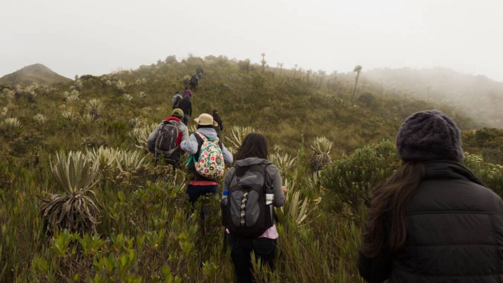
Just a short drive from Colombia’s bustling capital of Bogotá lies a hiking experience that transports visitors to what feels like another world entirely. The Lagunas de Siecha Trail in Chingaza National Park offers urban dwellers and travelers alike the chance to experience Colombia’s unique páramo ecosystem and discover a series of pristine mountain lakes nestled among the clouds.
Gateway to the Páramo
The Lagunas de Siecha trail is a 13.2-kilometer (8.2-mile) out-and-back journey that serves as one of the most accessible introductions to Colombia’s páramo ecosystem. This high-altitude tropical moorland, found only in the northern Andes, is a landscape of extraordinary ecological importance and otherworldly beauty.
Beginning near the town of Guasca at approximately 3,200 meters (10,500 feet) above sea level, the trail gradually ascends through rolling hills covered with frailejones – distinctive plants with fuzzy, silver-green leaves that are uniquely adapted to the harsh conditions of high altitude. These iconic plants, some of which can live for centuries, create a landscape that feels almost prehistoric, their silvery silhouettes standing like sentinels across the misty moorland.
What makes this hike particularly special is its accessibility. While many páramo ecosystems require multi-day expeditions to reach, the Lagunas de Siecha trail offers a day-trip opportunity to experience this unique environment. For visitors to Bogotá with limited time, it provides a perfect window into one of Colombia’s most distinctive ecosystems without requiring extensive travel or preparation.
The Three Lagoons: Mirrors of the Sky
The culmination of the hike is reaching the three beautiful lagoons of Siecha – pristine mountain lakes whose crystal-clear waters reflect the surrounding landscape and changing sky. These high-altitude lakes, situated at around 3,800 meters (12,500 feet), were considered sacred by the indigenous Muisca people who inhabited the region before Spanish colonization.
Each of the three lakes has its own character and charm. The largest offers expansive views across its waters to the surrounding páramo landscape, while the smaller lagoons provide more intimate settings, often shrouded in mist that parts occasionally to reveal their beauty. On clear days, the deep blue of the lakes creates a striking contrast with the golden-green of the páramo vegetation and the dramatic sky above.
Beyond their aesthetic appeal, these lakes represent a vital ecological resource. Chingaza National Park, with its 60 lagoons, provides approximately 80% of the drinking water for Bogotá’s 8 million residents. The páramo ecosystem acts as a natural water factory, with its specialized vegetation and soils capturing moisture from the air and gradually releasing it into the watershed. This makes the conservation of these fragile environments not just a matter of preserving natural beauty, but of ensuring water security for Colombia’s capital city.
Planning Your Lagunas de Siecha Trail Hike
The Lagunas de Siecha trail is considered moderately challenging, primarily due to the effects of altitude rather than technical difficulty. The thin air at 3,800 meters can make even gentle ascents feel demanding, and visitors from lower elevations should take their time and stay well-hydrated. Spending a couple of days in Bogotá (which sits at 2,600 meters) before attempting this hike can help with acclimatization.
The park has implemented visitor caps (40-60 people per day) to protect the fragile ecosystem, making advance planning essential, especially on weekends and holidays. The best time to visit is during the dry season from December to March, though morning mist and afternoon showers are common year-round in this cloud-forest environment.
Weather conditions can change rapidly, with sunny skies quickly giving way to dense fog or rain. Layered clothing, rain gear, sun protection, and plenty of water are essential for a comfortable experience. The trail can be muddy and slippery in sections, so proper hiking boots are recommended.
For nature enthusiasts, the Lagunas de Siecha trail offers opportunities to spot some of Colombia’s unique wildlife, including the possibility of glimpsing spectacled bears, white-tailed deer, and numerous bird species including the majestic Andean condor.
The Lagunas de Siecha hike represents a perfect synthesis of accessibility and wilderness experience – a journey that connects hikers to one of Colombia’s most unique ecosystems while providing insights into the critical ecological services these high-altitude environments provide to the country’s population centers below.
8. Volcán Puracé Trail In Puracé National Park

In the southern Colombian Andes, where the earth’s fiery heart still beats close to the surface, lies one of the country’s most exhilarating hiking experiences – the trail to Volcán Puracé. This active volcano, standing at 4,650 meters (15,255 feet) above sea level, offers adventurous hikers the rare opportunity to peer into the crater of a living volcano in a setting of stark, primeval beauty.
A Journey to the Mountain of Fire
The Volcán Puracé trail begins at approximately 4,050 meters above sea level, already placing hikers in a realm where the air is thin and the landscape bears little resemblance to the tropical image many associate with Colombia. From this starting point, the 8-10 kilometer (5-6 mile) round-trip journey traverses a landscape shaped by volcanic forces over millennia.
What makes this hike particularly special is that Puracé is the only active volcano in Colombia with a summit that’s considered safe to reach. While the volcano has experienced numerous eruptions throughout its history, with the most recent significant activity occurring in the 1970s, it is carefully monitored by volcanologists who ensure that visitors can safely approach the crater when conditions permit.
The name “Puracé” comes from indigenous language and means “mountain of fire,” a fitting description for this imposing peak that has played a central role in the mythology and cultural traditions of the region’s indigenous communities for centuries. As you ascend the trail, it’s easy to understand why ancient peoples would have regarded this smoking mountain with a mixture of awe and reverence.
The Crater: A Window into Earth’s Interior
The trail follows a gradual ascent on rocky, scree-like terrain, winding through páramo landscapes dotted with frailejón plants whose fuzzy leaves shimmer silver in the sunlight. While not technically difficult, the high altitude makes this a challenging hike, with each step requiring more effort as the oxygen content of the air diminishes.
The reward for this exertion comes as hikers reach the edge of the volcano’s crater, where the earth seems to open up to reveal its molten heart. Steam and sulfurous gases rise from fumaroles, creating an otherworldly atmosphere that engages all the senses – the mineral smell of sulfur, the sound of escaping gas, the heat that radiates from certain areas of ground, and the visual spectacle of the crater itself.
On clear days, the views from the summit extend across the Central Cordillera of the Colombian Andes, with neighboring volcanoes and the patchwork of farmland in the valleys below creating a panorama of extraordinary beauty. The stark contrast between the barren volcanic landscape at the summit and the lush valleys visible in the distance highlights Colombia’s remarkable ecological diversity.
Planning Your Hike To Volcán Puracé
The Volcán Puracé trail requires a good level of physical fitness, primarily due to the effects of altitude rather than technical difficulty. Prior acclimatization is strongly recommended, with many hikers spending a few days in the nearby city of Popayán (at 1,760 meters) before attempting the ascent.
A local guide is mandatory for this hike, not only for safety reasons but also because they can provide valuable insights into the volcano’s geological features and cultural significance. Guides can be arranged in Popayán or at the park entrance.
The best time to attempt this hike is during the dry season from December to March, when clearer skies offer better visibility and there’s less chance of trails being obscured by clouds or mist. Morning starts are essential, as afternoon weather patterns often bring clouds that can obscure the views and make navigation more challenging.
Warm layers, rain gear, sun protection, plenty of water, and high-energy snacks are essential equipment for this hike. The weather at high altitude can change rapidly, and temperatures at the summit can be significantly colder than at the trailhead.
For those interested in wildlife, the park is home to a reintroduction program for the Andean condor, with several of these magnificent birds released in the area since 2002. Lucky hikers might spot these massive birds soaring on thermal currents above the volcanic landscape.
The Volcán Puracé trail offers more than just a hike – it’s a journey to one of the places where the living earth reveals its dynamic nature, providing a humbling reminder of the powerful geological forces that have shaped Colombia’s dramatic landscapes over millions of years.
9. Caño Cristales Trail In Serranía de La Macarena National Park
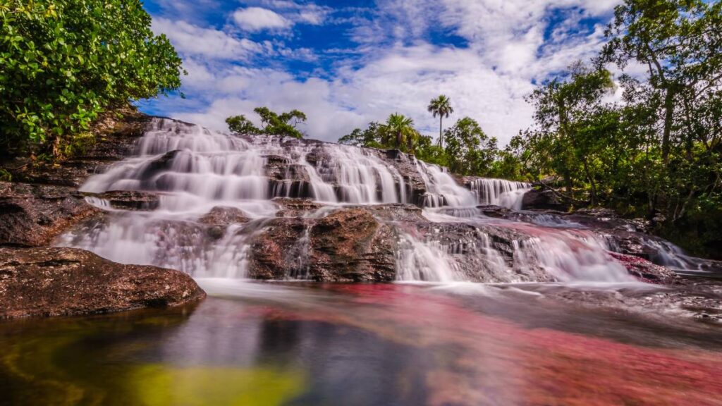
In the remote eastern plains of Colombia, where the ecosystems of the Amazon, the Andes, and the Orinoco converge, lies one of the country’s most extraordinary natural wonders – Caño Cristales, often called “the river of five colors” or “the liquid rainbow.” This unique waterway and the trails that follow its course offer visitors a hiking experience unlike any other in the world, showcasing a natural phenomenon that seems almost too vibrant to be real.
The River That Ran Away from Paradise
The Caño Cristales experience begins with a journey to the small town of La Macarena, itself an adventure as this remote outpost is primarily accessible by air from Bogotá or Villavicencio. From La Macarena, the adventure continues with a 20-minute boat ride up the Río Guayabero, followed by a short jeep ride to the trailheads that lead to different sections of this remarkable river.
What makes Caño Cristales truly unique is the presence of an aquatic plant called Macarenia clavigera that grows on the riverbed. During the wet season, the river flows too quickly and with too much sediment for the plants to display their colors. During the dry season, the water levels are too low for the plants to thrive. But for a magical period between these extremes – typically from July to November – conditions are perfect, and the plants bloom in vibrant shades of red, pink, yellow, and green, creating a living rainbow that flows through the landscape.
The trails that follow Caño Cristales vary in length from 3-5 kilometers each, with different routes showcasing various sections of the river and its tributaries. These paths wind through savanna and forest, leading to viewpoints where hikers can marvel at the kaleidoscope of colors flowing beneath crystal-clear waters.
A Symphony of Colors and Natural Pools
As you hike alongside Caño Cristales, the landscape reveals itself in stages, each more impressive than the last. In some sections, the river flows gently over beds of vibrant red plants that ripple like underwater flames. In others, it cascades over natural rock formations, creating small waterfalls and pools where the colors seem to dance and shift with the movement of the water.
One of the most magical aspects of the Caño Cristales experience is the opportunity to swim in designated natural pools along the river. Immersing yourself in these pristine waters, surrounded by the vivid colors of the riverbed below, creates a sense of connection to this unique ecosystem that goes beyond mere observation.
The river itself is relatively small – never exceeding 20 meters in width and running for less than 100 kilometers in length. This intimate scale allows hikers to appreciate the details of this natural wonder, from the texture of the plants that create the colors to the small fish that dart through the clear waters.
Planning Your Caño Cristales Trail Hike
The Caño Cristales trails are not particularly challenging in terms of terrain or elevation, with most routes following relatively flat paths through the savanna and forest. The main challenges come from the tropical heat and humidity, which can be intense, particularly during midday.
Access to Caño Cristales is strictly regulated to protect this fragile ecosystem. Visitor numbers are capped at 200 per day, and advance booking is essential, especially during the peak color season. All visits must be arranged through authorized tour operators, and a guide is mandatory. These measures, while sometimes frustrating for spontaneous travelers, are crucial for preserving the delicate balance that allows this natural wonder to exist.
The best time to visit is from July to November, when the Macarenia clavigera plants display their vibrant colors. Within this window, September and October typically offer the most spectacular displays. It’s worth noting that the park is closed during parts of the rainy season (approximately December to May) to allow the ecosystem to recover.
Visitors should bring quick-dry clothing, water shoes or sandals for river crossings and swimming, sun protection, insect repellent, and plenty of water. Photography enthusiasts will want to bring polarizing filters to reduce glare from the water surface and capture the colors of the riverbed more vividly.
The Caño Cristales experience represents a remarkable conservation success story. This region was previously inaccessible to tourists due to Colombia’s internal conflict, but since opening to visitors in 2009, it has become a symbol of the country’s journey from conflict to peace and its commitment to sustainable tourism and conservation.
For those willing to make the journey to this remote corner of Colombia, the Caño Cristales trails offer more than just a hike – they provide access to one of the world’s most unusual and beautiful natural phenomena, a living rainbow that flows through the heart of this diverse and fascinating country.
10. Valle de Cocora Loop In Los Nevados National Park
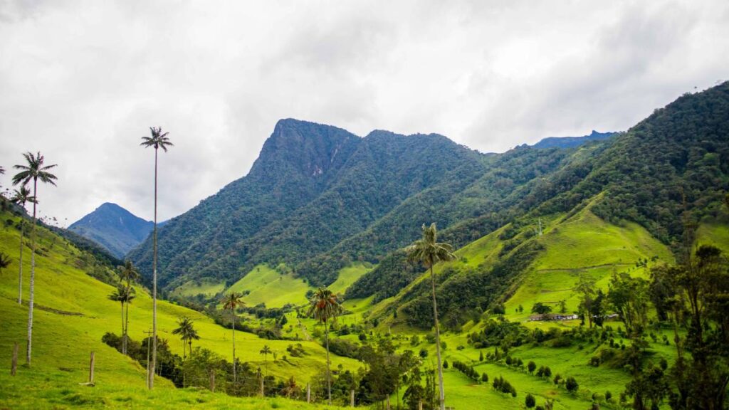
In the southern reaches of Los Nevados National Park lies one of Colombia’s most iconic landscapes – the Valle de Cocora. While we’ve already explored the Cocora Valley Trail, this final entry focuses on the complete Valle de Cocora Loop, a more extensive circular route that offers hikers a comprehensive experience of this extraordinary ecosystem, from cloud forests to the famous wax palm groves that have made this valley internationally renowned.
A Circular Journey Through Colombia’s Most Iconic Landscape
The Valle de Cocora Loop is a 10-12 kilometer (6-7.5 mile) circular trail that takes hikers on a journey through multiple ecosystems and offers some of the most spectacular viewpoints in Colombia’s coffee region. This well-established route provides a more immersive experience than shorter visits to the valley, allowing hikers to appreciate the full diversity and beauty of this unique landscape.
Most hikers tackle the loop counter-clockwise, beginning with a challenging ascent through dense cloud forest. This section of the trail follows the course of the Quindío River, crossing several rickety wooden bridges that sway gently underfoot, adding a sense of adventure to the journey. The forest here is lush and atmospheric, with moss-draped trees, colorful orchids, and the constant chorus of birds and insects creating an immersive sensory experience.
After approximately an hour of hiking, the trail reaches Acaime, a hummingbird sanctuary where hikers can take a break and observe several species of these iridescent birds as they dart between feeders. This peaceful spot offers a chance to rest before tackling the steepest section of the trail, which climbs to Finca La Montaña, a traditional farm perched on a ridge with panoramic views of the surrounding landscape.
Panoramic Vistas and the Valley of Palms
From Finca La Montaña, on clear days, hikers are rewarded with breathtaking views across the entire Cocora Valley, with the craggy peaks of Los Nevados National Park visible in the distance. This vantage point offers perhaps the best perspective on the valley’s unique topography – a series of undulating green hills punctuated by the slender silhouettes of wax palms that seem to defy gravity as they reach toward the sky.
The final section of the loop descends from the finca through open pastureland and into the heart of the valley, where the highest concentration of wax palms creates the landscape that has become an emblem of Colombia. The Quindío wax palm (Ceroxylon quindiuense), Colombia’s national tree, can reach heights of up to 60 meters (196 feet), making them the tallest palm species in the world. Some of these remarkable trees are believed to be over 100 years old, silent witnesses to the changing face of Colombia over generations.
The trail winds through this surreal landscape, offering countless photo opportunities as the light plays across the valley, creating ever-changing patterns of shadow and illumination. The final stretch returns hikers to the starting point, completing a circuit that showcases the remarkable diversity and beauty of this special corner of Colombia.
Planning Your Valle de Cocora Loop Hike
The Valle de Cocora Loop is considered moderately challenging, with some steep ascents and descents, particularly in the first half of the counter-clockwise route. The complete loop typically takes 5-6 hours to complete, though many hikers spend longer to fully appreciate the scenery, take photographs, and enjoy refreshments at Acaime or Finca La Montaña.
The trail can be muddy and slippery, especially during or after rain, making proper footwear essential. Hiking poles can be helpful for the steeper sections and river crossings. Weather conditions can change rapidly, with morning sunshine giving way to afternoon mist and rain, so layered clothing and rain protection are advisable regardless of the forecast.
The hike begins just outside the colorful colonial town of Salento, one of Colombia’s most popular tourist destinations in the coffee region. Jeeps known as “Willys” depart regularly from Salento’s main plaza to the trailhead, making access relatively straightforward.
While the trail can be hiked year-round, the best time to visit is during the dry seasons (December to March and July to August), when clearer skies offer better views of the surrounding mountains and there’s less chance of muddy trails. Morning starts are recommended to avoid afternoon clouds that often obscure the valley.
The Valle de Cocora Loop represents the perfect synthesis of Colombia’s natural and cultural heritage – a landscape shaped by the interplay of natural forces and human activity over centuries. It offers not just spectacular scenery but also insights into the traditional farming practices that have shaped this region and the conservation efforts now underway to protect its unique ecosystem for future generations.
As you complete this circular journey through one of Colombia’s most beloved landscapes, you’ll understand why the Valle de Cocora has become not just a must-visit destination but a symbol of Colombia itself – a place where natural beauty, cultural heritage, and biodiversity combine to create an experience that captures the essence of this remarkable country.
Embracing Colombia’s Incredible Biodiversity
Colombia’s national parks offer some of the most diverse and rewarding hiking experiences in South America, if not the world. From the ancient ruins of Ciudad Perdida to the otherworldly colors of Caño Cristales, from the towering wax palms of Valle de Cocora to the volcanic landscapes of Puracé, these ten trails represent the remarkable ecological and cultural diversity that makes Colombia such a compelling destination for outdoor enthusiasts.
What sets Colombia apart as a hiking destination is not just the variety of landscapes but the accessibility of different ecosystems within relatively short distances. In few other countries can you experience tropical beaches, cloud forests, high-altitude páramos, and snow-capped peaks within the same region. This ecological compression creates opportunities for hikers to witness dramatic transitions between ecosystems and experience the full spectrum of Colombia’s biodiversity in relatively compact itineraries.
As Colombia continues to emerge as a premier ecotourism destination, the importance of sustainable and responsible hiking practices cannot be overstated. Many of these trails pass through fragile ecosystems and territories with significant cultural importance to indigenous communities. By respecting park regulations, hiring local guides, minimizing environmental impact, and engaging respectfully with local communities, visitors can help ensure that these natural treasures remain pristine for generations to come.
Whether you’re drawn to Colombia for its archaeological wonders, its unique flora and fauna, its dramatic mountain landscapes, or simply the joy of discovering trails less traveled, these ten hikes offer windows into the soul of a country whose natural and cultural wealth is only beginning to receive the international recognition it deserves.
As you plan your Colombian hiking adventure, remember that while this guide provides a starting point, each of these trails holds countless discoveries that can only be fully appreciated through personal experience. The real magic of hiking in Colombia lies not just in the destinations highlighted here, but in the unexpected moments of wonder that await around each bend in the trail.
So lace up your hiking boots, pack your sense of adventure, and prepare to discover the breathtaking natural diversity that makes Colombia one of the world’s most exciting emerging hiking destinations. The trails await, each offering its own unique journey through this remarkable country’s natural and cultural landscape.
I have been running mindful hiking retreats for the last 7 years that integrate mindful awareness, experiential learning and community building practices.
I have been an experiential learning designer for over a decade through my company DIY Genius, which helps creative people productize their expertise.
I love flying my drone and sharing my adventures on my Instagram.
- 10 Best Multi-Day Hikes In Banff And The Canadian Rockies - April 18, 2025
- The 10 Best Hikes At Lake O’Hara In Yoho National Park - April 18, 2025
- The 10 Best Hikes In Banff National Park For Summit Views - April 18, 2025